METEORA
INFORMATION SYSTEM FOR MULTI-LEVEL DOCUMENTATION OF RELIGIOUS SITES AND HISTORIC COMPLEXES
For more information visit Hyperion’s website: https://www.meteora.net.gr/en/main/
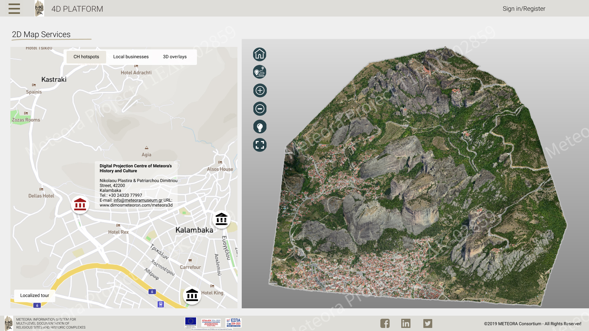
The aim of the project “INFORMATION SYSTEM FOR MULTI-LEVEL DOCUMENTATION OF RELIGIOUS SITES AND HISTORIC COMPLEXES” with acronym “METEORA” is the creation of a web-based platform for the management, visualization and dissemination of the products of multi-level documentation of the Archaeological/Holy Site of Meteora, and particularly, the rock of St. Modestos – Modi – and the rock of the Chain of Apostle Peter – Alyssos, on top of which ruins of non-accessible old monasteries exist. The results of the three-dimensional (3D) geometric documentation of the study area, combined with the non-spatial information derived from scientific research and systematic literature review, compose the information background of the web-based platform. Its content and interactive services are differentiated, based on the scientific specialty and the field of interest of the users of the platform, serving their different needs and requirements based on properly structured scenarios of use. The 3D models are visualized within the platform using advanced web development and web graphics methods within a multi-resolution visualization system. The difference in resolution (fourth dimension – 4D) is achieved by introducing the models as structures of different levels of detail; the structure of the proper level of detail is dynamically displayed as the user navigates within the 3D scene. Also, the system includes a model of the 3D reconstruction of the destroyed monastery of St. Modestos, for representation of its previous situation. The platform comes with a mobile Augmented Reality app for Android devices, which superimposes this model on the real world scene.
OBJECTIVES:
The main objective of the METEORA project, i.e., the management, the spatial and logical correlation and the visualization of data related to the documentation of the case study area, within the web-based ‘METEORA’ platform, is divided into the following sub-objectives:
• Design of the platform front-end interface and development of a user-friendly graphical user interface (GUI) with the following main features: (i) web-based visualization of 3D and 2D data; (ii) retrieval of multimedia information in real time; and (iii) integration of tools for interaction with the 3D scene. The system is completed by the back-end interface and the administration system for storing and organizing structured data in a well-defined relational database. The maintenance and visualization of high-resolution 3D models by the multi-resolution visualization system and the dissemination of metric and non-metric information in a clear and educational way are basic criteria for the design and development of the platform. The dissemination of data is achieved through data retrieval services, both directly from the relevant 3D monuments and through search fields for key properties and keywords. Thus, data of heterogeneous origin, format and field of interest are handled and correlated within the platform. The platform and its individual subsystems will be products of commercial exploitation as standards for use in documenting sites of archaeological, historical or religious significance.
• Definition of different user categories with personalized content. The access to the basic functionalities and information of the ‘METEORA’ platform is free for all users. In this general case, the category of tourist / simple user (unauthorized user) belongs. Other types of users are provided with the ability to create an account, so that they can redirect to personalized services and information based on their specialty.
• Development and implementation of innovative techniques for fast, low cost and high precision geometric documentation of inaccessible cultural heritage sites. The 3D models of high resolution and geometric accuracy are generated using innovative methods of data collection, data processing and 3D modelling, lying in the fields of photogrammetry, topography and computer vision.
• Development of a mobile Augmented Reality app for superimposition of the previous situation of the monastery of St. Modestos in the real world scene. The mobile app is developed independently of the platform, with the main goal of enhancing the navigation experience of the users, through an interactive way.
CASE STUDY:
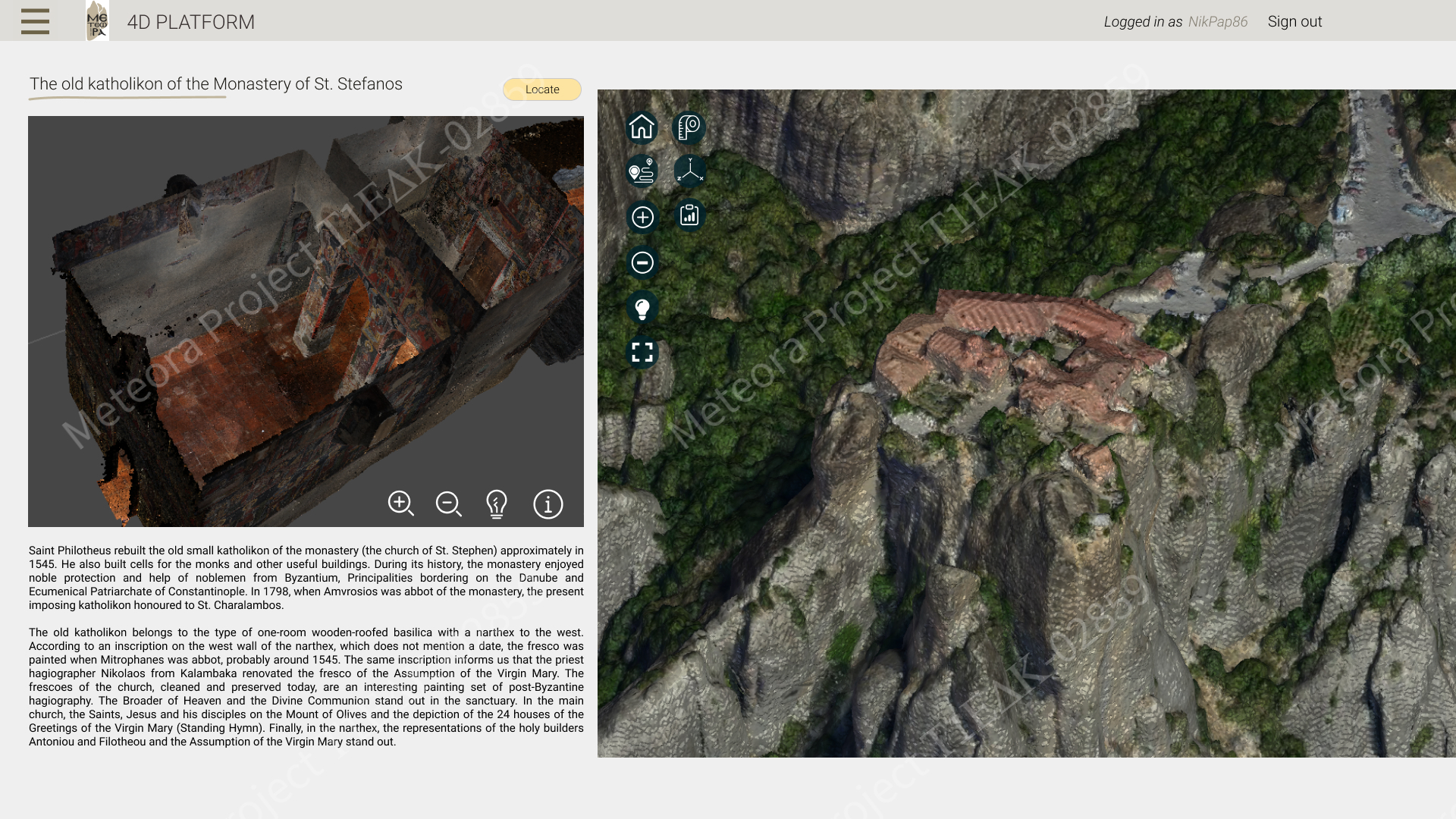
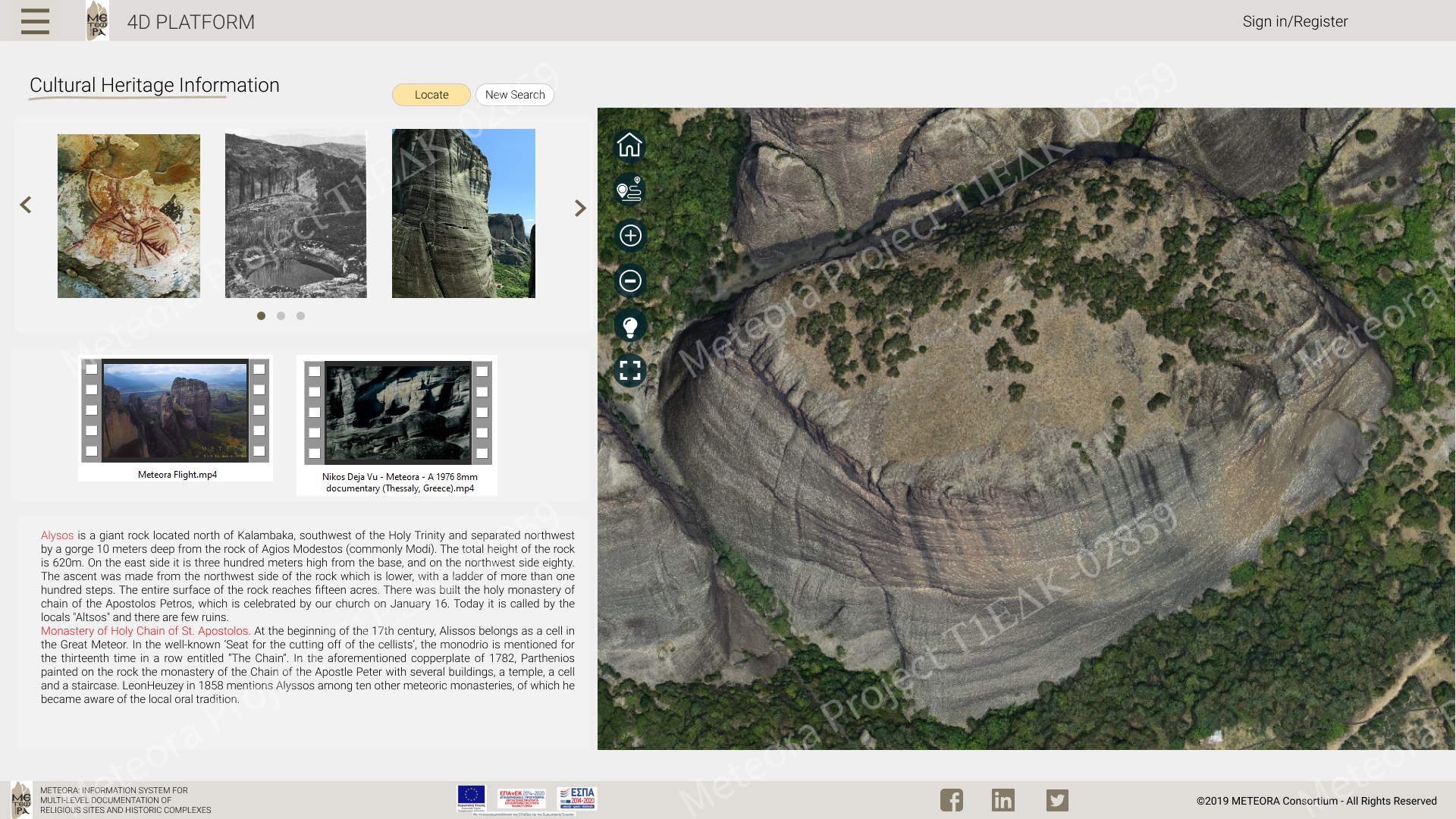
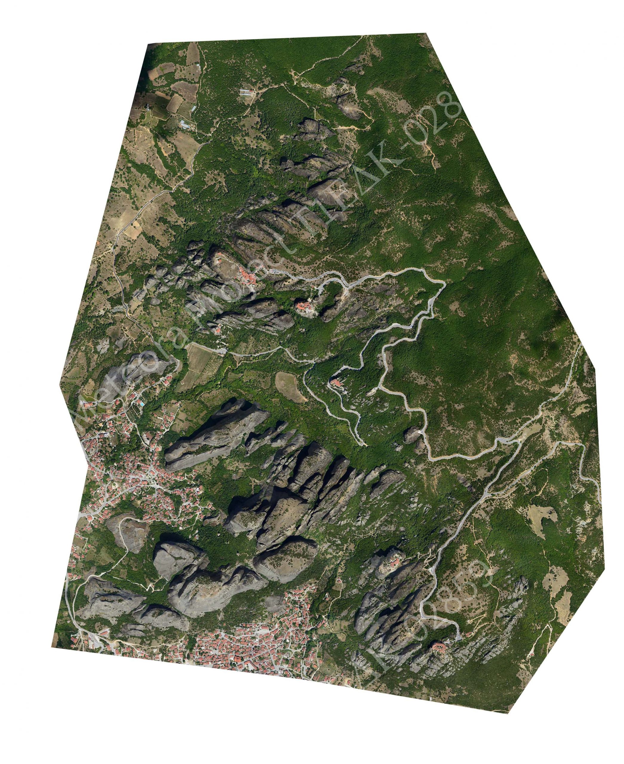
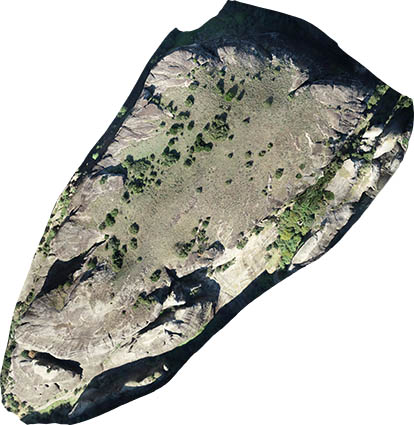
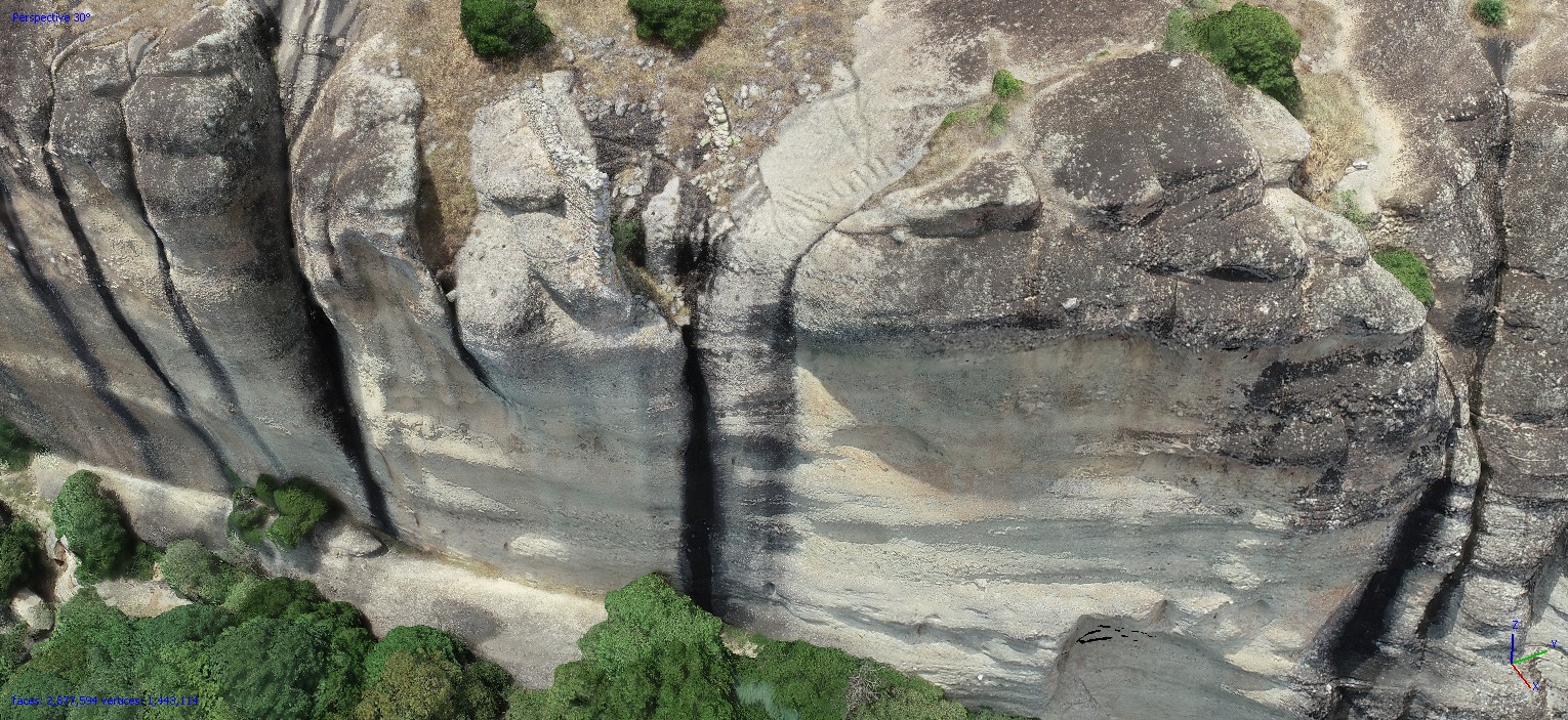
The METEORA project aims at the documentation and digitization of a part of the Archeological Site of Meteora. Particularly, the main study area consists of two inaccessible rocks: the rock of St. Modestos (‘Modi’) and the rock of the Chain of Apostle Peter (‘Alyssos’). At the top of both rocks, there are ruins of old Monasteries. Within this project, the Monastery of the St. Modestos is being digitally reconstructed; it is visualized both via the visualization system of the platform and through the Augmented Reality app. The choice of these two rocks lies in the existence of important findings, in the unexplored – until today – establishment and evolution of their monastic community as well as in the special topography and geological morphology. Apart from Modi and Alyssos, the study area includes the majority of monuments in the Holy Site of Meteora, including the six active Monasteries, the Pyxari rock, as well as some hermitages and other cultural heritage sites in the wider area.
Meteora is located near the city of Kalambaka, in the northwestern part of Thessaly, at an altitude of about 600 meters above sea level. It has been declared as an Archeological Site, and more specifically as a “Historic Preserved Monument” with the decision no. 10977/16.5.1967 of the Minister of the Presidency of the Greek Government. This declaration extends the protection of Meteora to the wider area beyond the building complexes of the monasteries. Meteora includes two Protection Zones. It has been declared as a Holy Site (Law 2351/1995), as it includes one of the most important complexes of Orthodox monasteries in Greece, with an active monastic community of a long history. At the same time, it is a special geological phenomenon with giant rocks that were generated 23 million years ago. At the tops of some of these rocks, six Monasteries were built and are still operating, while throughout the area there are some smaller abandoned monasteries and churches of the 14th century. Meteora has been characterized as an UNESCO World Heritage Site (https://whc.unesco.org/en/list/455/), based on the cultural criteria of UNESCO (C 1-5) as well as on a criterion concerning the natural environment (N 7). Meteora has also been proposed as a monument of geological heritage thanks to its important geomorphology. The area of Meteora along with the Antihasia Mountains are included in the European network of protected areas NATURA 2000 with code GR1440003, which is the main European means for the conservation of natural habitats, wild fauna and flora.
SPATIAL DATA:
Flight planning: The geometric documentation of cultural heritage sites of such extent and morphological complexity as that of Meteora needs specialized techniques. The metric and imagery information has to be geometrically accurate and of high quality, resulting from economic, fast and automated methods. Techniques of aerial photogrammetry are recommended for mapping large and inaccessible areas with the above requirements. Within this project, conventional aerial images from manned or unmanned aerial vehicles are captured and airborne laser scanning is also implemented (airborne LiDAR – Light Detection And Ranging). 2220 vertical and oblique aerial images were captured by a manned aircraft, covering the entire site of Holy Meteora, i.e., an area of 10km2. A camera of type NIKON D800E with a lens corresponding to a focal length of 50 mm was used. Each image has a size of 7360 × 4912 pixels. The images were taken from a low altitude and correspond to an average scale of 1: 20,000. They were collected in July 2017. About 50 ground control points (GCPs) were collected through RTK GPS measurements for the scope of georeferencing. In order to capture the rocks Modi and Alyssos in greater detail, a Phantom IV RTK unmanned aerial vehicle (UAV) with a 20 MP camera was used and a total of 5000 vertical and oblique images were acquired. Special targets were placed on the ground for georeferencing purposes and their coordinates were determined using a dual-frequency GNSS receiver. Also, the coordinates of specific points on the rocks were determined by topographic measurements .
Planning of scans: LiDAR systems, provided by Geosystems Hellas S.A., were used for scanning the Archaeological Site of Meteora, where the rocks Modi and Alyssos are located. LiDAR is a remote sensing method that uses pulsed laser to generate altitude data in the form of point clouds. LiDAR systems are suitable for mapping areas with vegetation and for applications that require quick response. Before performing the laser scanning stage, it is necessary to determine the parameters that will ensure the acquisition of a dense point cloud with satisfactory accuracy. Within this project, the dual-channel airborne mapping system RIEGL VQ-1560i-DW was used. This system incorporates 2 band LiDAR sensors (one activated in near infrared and one in green) in the same cone, as well as two photogrammetric digital aerial cameras of type Phase One IXU-1000RS; one camera captures color aerial images and the other one captures infrared aerial images. The data collection was supported by a GNNS system and an inertial sensor of type Applanix AV-610.
PROCESSING:
Generation of high-resolution 3D models: The vertical and oblique aerial images as well as the terrestrial images were oriented through the Structure from Motion (SfM) technique and a sparse 3D point cloud was generated. The SfM method simultaneously determines the camera poses, i.e., the camera exterior orientation parameters and optionally the camera interior orientation, and sparse 3D point clouds. The camera poses and the object geometry are determined by automatically locating homologous feature points (tie points) in overlapping images. The SIFT algorithm or its variants are mainly used for feature extraction and description. For each feature point, a descriptor vector is calculated based on its “neighborhood”. A RANSAC-based algorithm is generally used to identify and eliminate erroneous matches and improve the success rate of the SfM method. Large overlaps among the images are generally required for the successful implementation of SfM. In the context of the METEORA project, GCPs were measured in the field for the scope of georeferencing the SfM results. The Agisoft Metashape software as well as the RealityCapture software were used for comparative evaluation of the results. Then, dense point clouds were computed through a dense image matching process. For the implementation of dense image matching, computer vision algorithms (e.g., semi-global matching) are used to calculate the 3D object coordinates for each pixel, and not only the coordinates of the feature points. This process results in very dense point clouds, covering all parts of the object depicted in at least three images. During the last stage of the 3D modeling process, the 3D model of the scene is produced as a continuous surface, in the form of triangles (TIN) or other more advanced forms (curves, nurbs). The 3D surface model can be further enriched with texture mapping, thus including the maximum possible information. The creation of 3D surface models for the Archaeological Site of Meteora as well as the Modi and Alyssos rocks was implemented using the Geomagic Studio software.
Photogrammetric processing of LiDAR data and aerial images taken by the system RIEGL VQ-1560i-DW: As far as the processing of aerial images is concerned, the RAW RGB images were initially converted to .tif images. Then, the Phase One IXU 1000RS camera parameters were imported into the Erdas Imagine Professional software and tie points were automatically generated, as required for the aerial triangulation process. The processing of LiDAR data includes the conversion of LiDAR cloud points into the .las format and the organization of data in blocks of 500m × 500m so that they can be easily processed. Two procedures were applied for strip alignment through the Terrasolid Terrascan software:
- 1st application: strip alignment per scanner
- 2nd application: strip alignment per flight line


Prof. Charalabos Ioannidis
School of Rural & Surveying Engineering
National Technical University of Athens
http://users.ntua.gr/cioannid
Sofia Soile
MSc. in Geoinformatics
National Technical University of Athens
http://users.ntua.gr/smsoile
Styliani Verykokou
NTUA
http://users.ntua.gr/sveryk
Argyro Maria Boutsi
http://users.ntua.gr/iboutsi